Code for History

"Code for History" is a community that uses IT technology to solve historical problems. But I want to emphasize that for us, IT technology is "means" not "purpose". "Purpose" is about solving historical problems, so we use even non-IT methods if necessary. It's a community that puts the top priority on solving problems by any means.
[English] / [Japanese]
Code for History Activities
Read this document in Japanese / 日本語で読む
Development of Maplat
– Map for storied cities, Map for smart cities –
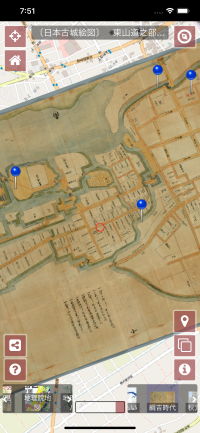 Maplat is a cool historical map and pictorial map viewer and is the only technology in the world that allows overlaying and switching over any maps while keeping topological homeomorphism and without distorting it (Patent No. 6684776, Kohei Otsuka). It can be used to walk around town or study history without spoiling the beauty of histrical maps or pictorial maps.
See these PDFs for details:
Maplat is a cool historical map and pictorial map viewer and is the only technology in the world that allows overlaying and switching over any maps while keeping topological homeomorphism and without distorting it (Patent No. 6684776, Kohei Otsuka). It can be used to walk around town or study history without spoiling the beauty of histrical maps or pictorial maps.
See these PDFs for details:
- Business side info (Japanese)
- Business side info (English)
- Technical detailed info (Japanese)
- Technical detailed info (English)
Maplat has several implementations for its purpose.
Maplat UI [github] [npm]
Maplat UI is Maplat with default UI.
If you put the configuration files on a web server, it will run without any server-side logic.
There is also an client-side API, so it can work with server-side logic.
Maplat Editor [github]
MaplatEditor is an editor for creating map data that works with the Maplat series.
As a desktop application, it runs on both Intel Mac and Win 64.
Installers are distributed in the site.
Maplat Core [github] [npm]
Maplat Core is API only version of Maplat.
All behaviors can be freely defined through the API.
Maplat Tin [github] [npm]
It is a library for generating the Constrained Triangulated Irregular Network, which is the heart of the operating principle of Maplet.
Maplat Transform [github] [npm]
It is a library for coordinate transformation that supports the operating principle of Maplat.
Nayuta, Inc. — Maintenance and Commercial Support
Code for History libraries are free to use. For the Maplat series, Nayuta, Inc. provides maintenance contract services and SaaS deployment. Other libraries are maintained on a voluntary basis; if you need commercial-grade maintenance, Nayuta, Inc. accepts consultations.
License note: The Maplat series libraries (Maplat, MaplatCore, MaplatTin, MaplatTransform, MaplatEditor) are licensed under the Apache License 2.0 from version 0.12.2 onward.
Operation of Maplat-applied sites
Case Studies
These are examples of commercial adoption.
- Yamagata Archive — a digital archive that brings together the town’s “memories” collected by the Yamagata University Museum and other archival institutions in Yamagata Prefecture, as well as by a student group at Yamagata University. Its map application (built with Maplat) lets visitors compare historical and current maps.
- Mitaka Onko-Chishin Map (Mitaka Network University, Tokyo)
- Soshigaya Childcare Map (Soshigaya Childcare Network, Tokyo)
- Maplat Tamamura (Gumma Shiryo-net)
Voluntary sites
Code for History runs several historical city map web sites for street walking for both Maplat demonstration and hobbyist purposes.
- Maplat Nara (Nara city)
- Maplat Tatebayashi (Tatebayashi city)
- Maplat Aizu Wakamatsu (Aizu-wakamatsu city)
- Maplat Iwaki (Iwaki city)
- Maplat Tokyo Chuo-ku (TOKYO Chuo city)
- Maplat Mito (Mito city)
Information links
Japanese
- QiitaのMaplat関連記事一覧
- Maplatの最新状況 –流行りのGTFSともコラボしてみた
- 古地図アプリMaplat、その後の進化
- FOSS4G Hiroshima 2026 — From Open Source to Real-World Impact — トーク(9/2)・スポンサーブース(9/3)
English
- A vision to make OSM data the backbone of history across time and space
- Introduction of HTGCL (Historical Topographic Ground Control Line)
- Maplat - Map application platform that utilizes historical maps and cultural assets
- FOSS4G Hiroshima 2026 — From Open Source to Real-World Impact — Talk (Sep 2) and Sponsor session (Sep 3)
Open source software development for open data in historical/ cultural heritage research
Weiwudi [github] [npm]
This is a framework for service workers who can control the cache of map tiles available offline, get the current cache capacity, download in advance in bulk, and delete the cache in bulk when creating a map application with PWA (Progressive Web App).
Information links
- Weiwudi (タイル地図アプリ向けPWAオフライン対応フレームワーク) (Japanese)
- タイル地図アプリ向けPWAオフライン対応フレームワークWeiwudiをベクトルタイルに対応させる宣言 (Japanese)
- Weiwudi – Service worker framework for map application (Japanese, English)
Torii [github]
Torii is a management program that enables efficient management of open data on cultural properties associated with location information.
It manages data master information in both Excel and GeoJSON, and when either is changed, both masters can be updated to match the change via intermediate data.
Information links
- アニメの聖地における地域歴史資料の活用と公開、普及施策 (Japanese)
Gyeonghwon [github]
This is a platform to easily create animated markers on the new map API using Animated images.
Now it supports Animated GIF, APNG and Animated webp.
Harumi [github]
Harumi is an open dataset and web converter for Japanese-Western calendar conversion.
Quyuan [github]
Quyuan is a GeoJSON template engine with an integrated multimedia viewer for map popups.
Chuci [github]
Chuci is a standalone multimedia swiper and viewer Web Components library, extracted from Quyuan.
Nagarjuna [github] (Under development)
Historical Open Data Creation / Distribution
Jizo Project [github]
It is an activity to collect the location and photographs of Jizo, stone Buddhist statues, small wayside shrines in Nara city and make it into an open database.
It is a project to rediscover the value of Nara’s historical and religious assets, which are considered to be denser than the convenience stores in metropolitan cities.
Tatebayashi Stone Monuments open database [github]
Some volunteers in Tatebayashi started a project about 50 years ago to collect the data of all stone monuments throughout the city and edited them as a series of five volumes named “Tatebayashi no Nobotoke Meguri”.
Code for History turns these volumes into open data and surveys how they are now.
The project aims to bring a new light to the forgotten achievements of 50 years ago, when valuable achievements were made.
Tile mapping of US Army “Japan City Plan” map [github]
Code for History works on the creation of tiled mapping data of the “Japan City Plan”, a collection of the University of Texas, which was used by the U.S. military to govern Japan immediately after the Pacific War.
This map could not be correctly converted into GIS data even if it was processed using the described geodetic and projection systems.
However, the conversion into GIS data was succeeded by identifying a method that can be processed by unraveling the details of how the map was created.
Open Data Collection of Poems by Himeji Poet Toru Otsuka [Wikisource]
Code for History is promoting a collection of poems by Toru Otsuka, a Himeji poet in the early Showa period, as open data at Creative Commons BY-SA 4.0.
It has been less than 70 years since his death and the copyright of them are not expired yet, but with the permission of the copyright successor, the publication on CC is proceeding.
Writing Wikipedia Articles on Historic Sites, Events, etc. [List]
Code for History is working to dig up forgotten historical sites and events and turn them into Wikipedia articles for future.
As a feature, the project provides uniqueness to make articles by investigating not only literature but also historical maps and geographical data.
Leading articles:”Kikai-ga-Shima (Nara)”,”Shogan-in temple”,”Playhouse in Kawarado”,”Yashima Mausoleum”,”Fukudera temple”,”Shimada shrine”,”Kodo Murai”,”Kasuga-utsushi”,”Belief of Gozu-Tenno in Tatebayashi”,”Obiki Inari shrine”,”Tea Granny”,”Shigemitsu Kitao”,”Toyoko Osawa”,”Toru Otsuka (Poet)”
Support for activities of other organizations
Including activities before the name Code for History was adopted.
Although not the main business, Code for History can help to the extent possible, if cooperation is possible through know-how utilizing old maps, chorography surveys, and library references, including consultation on how to apply Maplat.
Please feel free to contact Code for History.
Assistance in Locating Ainu Names in Hokkaido
In the production of historical place name data by National Institutes for the Humanities, cooperation was provided by providing location identification technology for places where the location could not be identified due to a large amount of displacement and distortion in the old version of the topographic map when the location was identified from the topographic map with a scale of 1: 50,000.
Cooperation with the “Hiroshima Archive”
Code for History cooperated with Professor Hidenori Watanabe and his staff in providing an open source library that reads topographical data from the Geospatial Information Authority of Japan to “Hiroshima Archive” a site that preserves memories and testimonies of the Hiroshima atomic bomb.
Cooperation and support for Maplat applications
Code for History helped with the implementation of Maplat applications which are not operated by Code for History.
Some of them cannot be published, but the following are some examples that can be published.
- Supporting the application of Maplat (Maplat Android, Maplat iOS) to the “Sightseeing cloud application” of the Machidukuri-Platform Co., Ltd.
- Support for application of Maplat (Maplat UI) to “Higashinari City Walk App” in Higashinari Ward, Osaka City
Investigation of the origin of great figures and historic sites
There are many projects that cannot be opened to the public, but Code for History has provided support mainly for historical maps, chorographies, and library surveys for great figures and historic sites.
What we will do in the future
GIS Open Data for Castle Structure
We would like to start with Tatebayashi Castle, then next are Himeji Castle, Aizu-Wakamatsu Castle, Iwaki-Taira Castle, Kanazawa Castle and Sendai-Aoba Castle.
First of all, we will create GIS data of defensive structures (Castle walls, moats, gates, etc.), and after that, we would like to work on the area polygon of town names in the castle town.
As a similar initiative, we plan to expand it to include data on the Naramachi area in Nara.
Historical Koaza position open data
The Center for Open Data in the Humanities is providing current Koaza position open data including the polygon boundaries.
We hope to extend it to include historical Koaza.
It may not be possible to include the polygon boundary, but I would like to start with Tatebayashi, even if it is just a representative point.
Provision of open data sightseeing POI
We would like to provide POI data on historical sites that can be used freely for sightseeing applications in various places.
As a feature, we would like to make it unique, including unique contents such as “Kikaigashima” and “Tea Granny”.
We would like to start with Tatebayashi, Nara, Himeji, Aizu-Wakamatsu, Iwaki, Kanazawa, Sendai and Nobeoka.